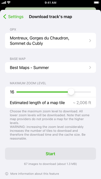
GPX viewer 2 is the brand new version of my first GPX viewer app! With new features, a new modern user interface and new interactions. I've listened to your needs and built a new app just for you! Import your tracks from GPX files (tracks or routes) into the app. Even if your file contains many tracks. Display their tracks on different preset base maps (plan, satellite, OpenStreetMap, OpenTopoMap, Swisstopo, IGN) or on any of your own custom base maps. Display an interactive elevation profile to evaluate track difficulty. And check out all of information contained into your GPX file (such as description, images, links, waypoints and stats). Track your position along the route during your hike by following the path on the interactive map. You can also view GPX points of interest, navigation tools (compass, GPS location, altitude) and a speedometer. The app even provides weather conditions at the starting point of your itinerary. All what you need to go hiking and follow your route... without ads! The only in-app purchases are tips for few other features, just take a look. GPX viewer is the app you need for your hikes and bike or motorcycle trips! Features details: - Import of GPX files via file, web link or from your Fitness app - Management of imported GPX (library) - Display GPX track on the map (track and route, also support multi-tracks) - Several base maps: map, hybrid, satellite 3D, OpenStreetMap, OpenTopoMap, Swisstopo - Possibility to set your own custom maps from a library or manually - Possibility to download maps for offline use - Displayed on the map: current position, start and end of the route, points of interest along the route, scale, route direction - Choice of color and size of the route - Color of waypoints's markers - Locking of screen standby to better follow the route - Map cache system - Display of GPX details: name, description, elevation profile, elevation differences, distance, altitudes, image gallery, link, points of interest, duration - Display details of a point of interest: name, description, image gallery, links, distance on the track - Support for audio links as an audio guide (on GPX and Waypoints) - Navigation tools: compass, GPS location, altitude - Weather condition at starting point - Access to the route via Maps, Google Maps or Waze - Sharing a GPX - GPX editor - Speedometer Note: Hey! If you can't open a file from my app, please contact me and provide me the file, I will take a look. What about GPX viewer 1? The app is still available on the App Store if your device is not compatible with GPX viewer 2.