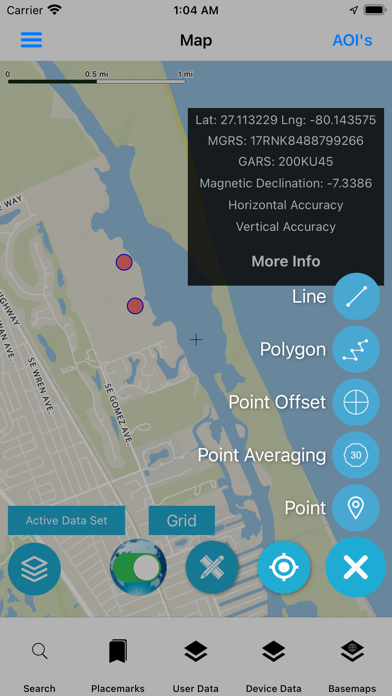
Geo Data Collector is an advanced field data collection mapping app Flexible form designer and adhoc in-app form building Supports saving data in GeoJSON and conversion to GeoPackage Vector Features and other formats coming soon. Form design is a JSON file that’s easily shared and distributed to other users. Design form on our form builder webpage https://mapdata.xyz/form_generator/ or in the app This works completely offline (all data is stored locally in the app) Does NOT Require any server-side database or ESRI featureserver or any API like OGC WFS-T to use this. NO proprietary formats. Supports capturing of Points, Lines or polygon geometry and Point Averaging and Point Offset Rapidly switch between forms Review collected data, edit collected data, delete a record, go to location on the map Add photos from camera or from Photos/Gallery Attribute table/grid with search for both collected data and user loaded data. Advanced vector tile basemap with 11 styles to choose from (online/offline) including a Terrain/Topo style, 3D Building style (when tilted), Bright,Positron, Toner, DarkMatter and hybrid Online raster tile basemaps from ESRI Optional in-app purchase for Offline Map Data (to users area of interest) OpenStreetMap Vector Tiles with more than 8 Stylesheets to choose from including Terrain/Topo Style Contour Lines Vector Tiles Hillshade Raster Tiles Satellite Imagery Raster Tiles GADM Boundary Support for user loaded mapping data: GPKG vector features (users can style their data also supports dynamic raster tiles generation for handling big data) GeoJSON Vector GIS Data with attributes (users can style their data) MBTILES - Raster tiles MBTILES - Vector tiles (users can apply a style their data) GPKG - Raster Tiles (EPSG:3857 web mercator only) In-App Vector Data Converter - convert User Zipped Shapefile (WGS84), KML, GPX, CSV, WKT to GeoJSON Vector Layers Reference overlays that can be turned on and displayed on the map Layer Display Order - to control the display of different data Advanced Map Features: Display Latitude and Longitude (MGRS and GARS GRIDS) Display Magnetic Declination Measure Linear and Area Distance Spatial Bookmarks - Placemarks feature - save reference to a spot with notes Advanced geolocation settings with follow (move the map) and follow with heading or course Other capabilities: Go to Coordinates - move the map to Lat Long or other coordinates Coordinate Converter Geolocation Sharing Weather Conditions/Forecast Sunrise/Sunset, Time, Timezone, Elevation GPS Tracker/Recorder - record track and share as GPX or GeoJSON Open Street Map Search (nominatim place names and addresses and overpass API for points of interests) Compass Settings to turn off coordinate box File Manager Office File (Word, Excel, Powerpoint) Viewer, PDF Viewer, Image Viewer Easily Upload and Download files via: Cloud Integration (Dropbox and SugarSync) FTP Server & WEBDAV servers WIFI Sharing - share content on your phone/tablet and even allow uploading of files via a webpage accessible on any device on the same network Intuitive easy to use interface Forms support (Text field, text area, select/drop down, number, date field, check box and radio button ) You can denote fields as required or optional For select/drop down you can allow the user to support multiple selections. No Need to build Project file with desktop GIS Software like QGIS or Global Mapper (Input, QFIELD, Global Mapper Mobile) There is no vendor lockin as there is no Back-end Service or Database Required Optimized for both iPhone and iPAD works with internal GNSS Receiver (iPhone and iPAD 4G/5G) as well as External Bluetooth GNSS Receivers We can Build custom Solutions to suit your needs and requirements and workflows geodatacollector@techmaven.net